Friday 19 October 2012

Post 3. HOW THE PRODUCT WILL MEET OUR USERS NEEDS

TARGET CUSTOMERS


The target customers/users of the application are predominantly researchers who are working to answer questions that relate to the topics of;
  • Climate change prediction of species distribution (Conservation)
  • Identifying Biodiversity Hotspots (Conservation / Agriculture)
  • Understanding Soil and Vegetation Communities (Agriculture)
  • Understanding the Conditions of Ecosystems (Conservation)

Other users of the application will include decision and policy makers from groups and organisations involved in Natural Research Management (NRM), such as State and Local Government Authorities (LGAs).
Soils2Satellites will support the investigation into the future management implications of temperature change, rainfall and drying for critical issues such as species genetic flow, refugia and evolutionary/extinction potential.

HOW THE PRODUCT WILL MEET OUR USERS NEEDS


The project will meet users needs through providing a publicly accessible web portal that provides users with the ability to select ALA-based species occurrence data and environmental layers, Auscover Satellite imagery and TREND plots data for exploration, display, comparison, link-to and/or download. 
The tool will support the exploration and visualisation of available relationships within the TREND and ALA data, including those relating to: species occurrence and environment; genetic diversity; spatial distribution and genetic variation at genes under selection and environmental variation; changes in environment in the past inferred from the distribution of genetic variation (e.g. refugia or genetic expansions).
The tools in the application will allow for data relationships to be explored in new ways, thus opening up ways to interpret existing information and/or exposing relationships between data that were not previously possible.
The Soils-to-Satellites tool will enable researchers to explore and display relationships between disconnected data sets in ways not previously experienced. For example, they will be able to display ’layers’ of Australian environmental data such as elevation, temperature or soil type, and then ‘ drill down’ to s to compare vegetation and genomics data across those layers (Diagram). Datasets identified through the tool will be provided to the ANDS ARDC at a collection level for further discovery by the research community.


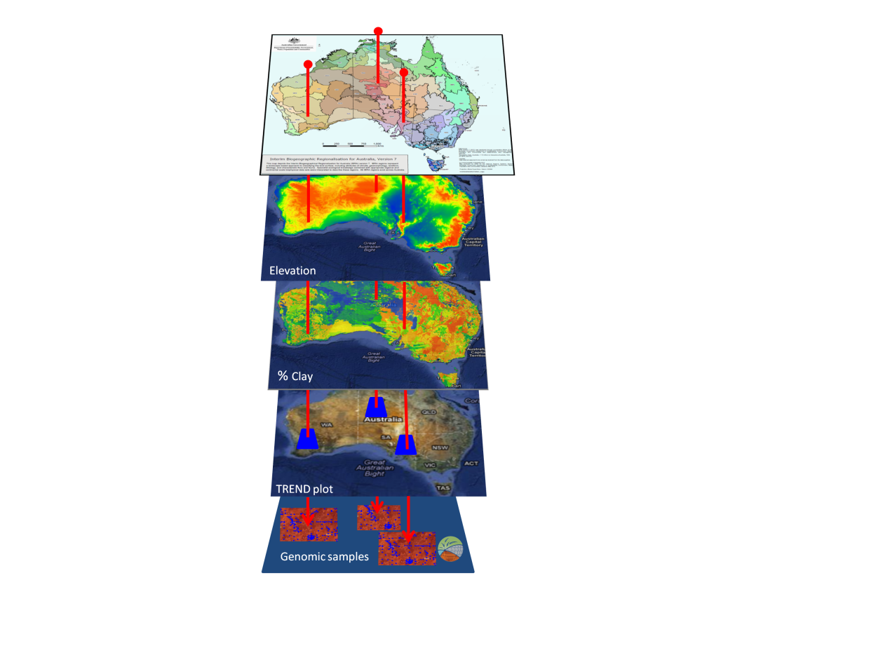
Diagram 1. A stylised diagram showing how information for three plots within a TREND transect (dark blue) can be displayed and analysed in detail by overlaying the spatial information of four layers at exactly the same location in each layer to view the genomic data collected at the ‘plot’ level and stored in the  ÆKOS  data portal (Source of IBRA, elevation and % clay - Atlas of Living Australia, TREND plot layer derived with Google Earth, genomic samples are illustrations only ). Soils-to-Satellites enables researchers to visualise sophisticated ecological and genomics data through an integrated application for the first time.

The application will also deliver RIF-CS service and data collections to ANDS to support further discoverability of the data.

Thursday 18 October 2012

Post 2. PRODUCT TEAM

Soils to Satellites is a collaboration between the Atlas of Living Australia and the TERN Eco-Informatics team from the University of Adelaide.  The collaboration would not have been possible without the support and funding from ANDS. 


The team from the Atlas of Living Australia


Peter Doherty - Project Manager

Peter has been the Program Manager for the Atlas since 2009 and, after having started out as a programmer before moving on to infrastructure systems, has an extensive career in the delivery and management of IT projects.

Dave Martin - Software Architect

Dave has been working in biodiversity informatics for 6 years, and prior to this has worked on healthcare and banking systems. He started working for the Atlas in 2008. Prior to this, he worked for the Global Biodiversity Information Facility (GBIF) in Copenhagen. He has skills in GIS, databases (relational, nosql), Lucene, Java, Scala, Groovy/Grails.

Dave Baird - Software Developer

Dave is an experienced analyst/programmer and has been a software engineer for 18 years.  Dave has been able to quickly pull together a demonstration environment using services from NECTAR and is using web services from the Atlas and as supplied by the TERN team to create the base S2S portal.  Dave was a key developer in the Biolink project and has strengths in:
  • Java/Scala 
  • RDBMS - MySQL, Postgres, Oracle, Ingres and SQLServer 
  • no SQL - Cassandra

Natasha Carter - Software Developer

Natasha has been working as a software engineer for 8 years.  She works for a small company that specialises in providing data integration solutions. She is experienced in the design and implementation of solutions using a variety of tools and technologies including:
  • Java/Scala 
  • RDBMS - MySQL, Postgres, Oracle, Ingres and SQLServer 
  • no SQL - Cassandra 
Natasha has been involved in the ALA since December 2009 contributing to the data and service layers.


Nick dos Remedios - Software Developer

Nick has been with the Atlas of Living Australia since 2008 and has been working as a software developer since 1999. Prior to that he worked as immunologist/molecular biologist/bioinformatician. He has experience in the areas of airline logistics, patent informatics and biodiversity informatics. He often gets pigeon-holed as front-end developer and spends most of his time coding in Java, Groovy, Javascript and HTML/CSS. Favourite frameworks/APIs include Grails, Spring MVC and jQuery.


Miles Nicholls - Data Manager

With a background as a business analyst in data warehousing and business intelligence Miles has been working with the Atlas since late 2009 as Data Manager.  Miles has  qualifications in science (although never used in anger and frighteningly out of date) and information systems and thinks it's great that the ALA combines the two.  Miles' work with the ALA involves discussing data sharing, open access licensing, data schemas and formats with the owners of data and transforming data using whatever tool will do the best job at the time.


The team from TERN Eco-Informatics


Martin Pullan - Project Manager

Martin has been working in IT for over 15 years and has been the IT Project Manager with TERN Eco-informatics for 18 months with responsibility for the AEKOS, SHaRED and S2S projects. Prior to this role he worked as an IT Project Manager in the South Australian government developing software applications that supported environmental monitoring and NRM activities.
    

Casper Yeow - Business Analyst

Casper has had over 13 years consulting in the Information Management industry, with experience in numerous business domains, primarily as a Business Analyst. He specialises in the areas of requirements gathering and analysis, business rules elicitation and process improvement.


Ben Till - Senior Software Developer

Ben is an enterprise software developer with 12 years experience. He has worked on projects all around Australia in domains including geospatial, emergency services, finance, real estate, correctional services and mobile applications. Ben has specialised skills in complex data processing.


Gilli Atkinson

Gilli is a Java Architect and software developer with over a decade of experience working in a range of government and private enterprise environments. He has worked on complex projects across Australia as a contract developer.

Post 1. PROJECT DESCRIPTION

A major component in ecological research is the discovery, visualisation and interpretation of the relationships between complex biological systems and their distribution in space and environment.

This project will explore the potential for visualising and analysing ecological and related data  from multiple plots and/or locations provided by the TREND SA project and spatial data from the ALA  - leading to the ability to make comparisons between these data.

“This one-year project unifies and combines spatial, multi-spectral remote sensing, ecological and genomics data in a single tool to meet the interdisciplinary data needs of scientists studying and managing Australian terrestrial ecosystems. Soils-to-Satellites will enable data users to analyse and display different types of research data more effectively,” says Craig Walker, Director of the Eco-informatics Facility of the Terrestrial Ecosystem Research Network (TERN) at The University of Adelaide.


For the first time, the project combines exemplar vegetation and genomics data produced by the TREND component of TERN’s Multi-Scale Plot Network (MSPN) facility with  the rich spatial and biodiversity information from the Atlas of Living Australia (ALA).  These TREND data will be supported by and provided from the TERN Eco-informatics ÆKOS data repository.


The Soils to Satellites tool will re-use and extend the existing infrastructure and functionality provided by the ALA’s open infrastructure and TERN Eco-informatics AEKOS platform.


Peter Doherty, Programme Manager of the Atlas of Living Australia, says “Thanks to support from ANDS and DIISRTE, this project is a great example of adding value to Australia’s investment in e-research assets.  We are pleased to be collaborating with the leading national research capabilities of the National Collaborative Research Infrastructure Strategy (NCRIS) for terrestrial ecosystems to build the Soils-to-Satellites tool.  Both teams are looking forward to combining our collective data infrastructure expertise and make ecosystem science even more productive and effective.”


This project is supported by the Australian National Data Service and the Atlas of Living Australia. Both capabilities are supported by the Australian Government through the National Collaborative Research Infrastructure Strategy Program and the Education Investment Fund (EIF) Super Science Initiative.